Main menu: Home Features 3D Maps User Guide Support Buy Now Disused Tube Blog

Overground to Chingford, Cheshunt and Enfield

Overground ExtensionWe’re a little puzzled here as to why this became a ‘news’ story again this week, when the Evening Standard ran a story that had already been confirmed back in July 2013 – that TfL were taking control of the West Anglia services out of Liverpool Street to Chingford, Cheshunt and Enfield.

In fact the only ‘new’ thing that we could find (but we’d assumed anyway) is that the new Overground service will indeed appear on the tube map.

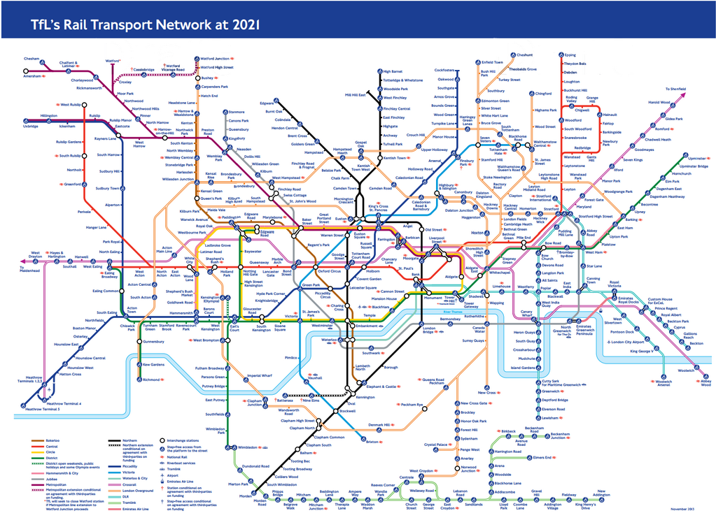
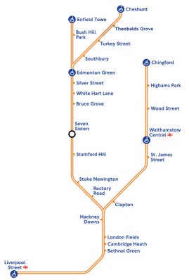
The ES and Time Out Blog (who got excited about it too) ran a clean map showing what the services would look like out of Liverpool Street, but what’s actually worth considering is how messy this is going to look when you throw in all the other tube lines – and Crossrail as well.
Knowing that TfL have publicly stated their desire to take over more inner suburban London rail services, to become ‘Overground’ too – at what point is the tube map going to look just too cluttered and TfL will have to bow to the pressure of a redesign?

Overground Extension Map Congestion

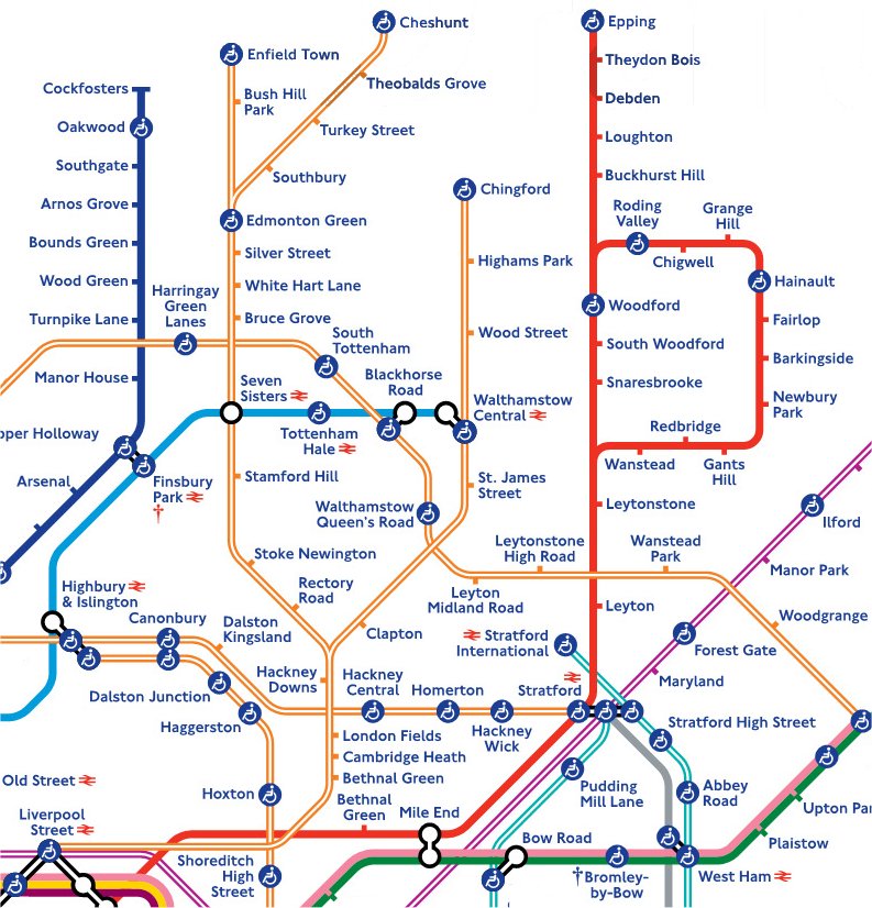
Of course, a map for all railway services already exists, but you don’t see this in printed pocket form at tube stations – and that’s where we suspect something new is going to have to be created. If they keep adding in new Overground lines, the map is going to look horribly cluttered and not that usable or readable at that size – look for example how squashed London Fields, Cambridge Heath and Bethnal Green already are – so surely something, somewhere, is going to have to change…

09 Jan 14

No Bakerloo or Northern at Embankment

No EmbankmentA reminder that work started today at Embankment station to replace the old escalators down to both the Bakerloo and Northern Line platforms, meaning that from today – and until November when it is projected work will be finished, only District and Circle line trains will be stopping at Embankment station.   This is actually the only new thing that we’ve spotted on the latest tube map, everything else looks the same as before!

No Embankment PosterTfL point out on their website, that it’s literally a 60 second walk up or down Villiers street between Embankment station and Charing Cross meaning you can get to your Bakerloo and Northern Line services there instead.


08 Jan 14

Detailed LU Track Map

Ah, you have to love the Freedom of Information Act, under which large companies and corporations are obliged to release certain information to the public upon request.

The latest gem to emerge is from a request to LU/TfL here, where someone had requested a detailed signalling and track plan map.

They don’t quite meet the requirements with their response (if you read it carefully you can see why they don’t have to), but they do link to a rather fabulous – and previously unseen by this Station Master – map of the Underground, a small section of which we’ve got for you here.

Follow this link for the full map, but be aware it’s 17MB in size, so will take a longer time to download on slow connections.

Pedants will note that it’s a little out of date where in concerns non-Tube lines, if you look closely at Stratford it still shows the old ‘Silverlink’ North London Line track which has now been replaced by the DLR.  You might argue too, that the Thameslink track to Barbican shouldn’t be shown, as this service no longer runs and is being turned into Crossrail, but it’s still a beautifully detailed map that even shows disused stations and unfinished ones (such as Bull & Bush on the Northern Line).

LU Track Plan Map

LU Track Plan Map


08 Jan 14

Piccadilly to Ealing Broadway … permanently?

Piccadilly Line to Ealing Broadway

Piccadilly Line to Ealing Broadway

A thought that’s been discussed before but one worth mentioning again here on the blog is what happens when the S7 stock trains are rolled out onto the District Line.

Let’s look at a couple of things that have been in previous posts here on this blog.  We know that 1973 stock Piccadilly trains can run to Ealing Broadway ok, and we know that S7 District trains are running in and out of Olympia in a regular hourly service.

So what happens when all the D-Stock trains are replaced?  When the current District trains are all replaced by S-Stock (by 2015) it raises up an interesting thought – why not swap round the western end of the District and Piccadilly Lines.

The Piccadilly could then concentrate on going to Heathrow, with a smaller ‘spur’ off to Ealing Broadway.  If there’s any disruption in service, Ealing Broadway could almost be considered an reversing siding for Picc trains to turn and come back again.

The District – using S-Stock – would then go on up to Rayners Lane and Uxbridge meaning that the same style stock would be used on the stretch of the line – rather than mixed height (as we have at the moment), meaning that it would be so much easier to make that stretch of the tube map have step-free from platform to the train, with just one type of train.

But running a District service from Upminster to Uxbridge is a loooong way, which is where Olympia comes into play.   You could have a District Line service that runs from Uxbridge to High Street Kensington, and an Upminster service that runs into Olympia, thus replacing the odd ‘shuttle’ that used to/still does take place between these two stations.

You might therefore see the District Line completely changing its service patterns to look like this:

Uxbridge to High Street Kensington
Wimbledon to Upminster
Wimbledon to Edgware Road
Uxbridge to Mansion House
Richmond to Upminster
Olympia to Plaistow
02 Jan 14

New step free access at Paddington

Hammersmith Lift

Hammersmith Lift

TfLAccess tweeted yesterday that the new lift at Paddington station (H&C branch) had opened early, so we popped down to go and see where it was.

The lift that takes you down from the canal entrance to ticket hall level has been open for a while, but this is the lift that takes you down to platfom level, and is at the western end of the platform.

Whilst there, we also noticed that all the temporary ‘quick ticket’ ticket machines have now been replaced with more regular/permanent ticketing machines.

Hammersmith Lift SIgn

Hammersmith Lift SIgn

This lift adds an important step-free station in the north west area of Zone 1 which is otherwise devoid, and with Paddington H&C now being almost totally serviced by S-Stock trains, means that level boarding is now possible too. It therefore should be a blue blob on the tube map, but the latest edition (showing no interchange at Embankment with the Northern and Bakerloo there) does not show it yet.


24 Dec 13

New tube map

There’s a new tube map out for December 2013 (No interchange at Embankment for Bakerloo or Northern Lines!), and as with all new tube maps, there’s a new piece of artwork for the cover, this time designed by Imran Qureshi who’s work is “underpinned by his interest in and reflection on the relationship between ancient, traditional life and contemporary life in Pakistan as well as the complex relationship between Islamic and Western life and culture”.  Read more on that over on the Art on the Underground website.

Tube Map Cover December 2013

Tube Map Cover December 2013

19 Dec 13

Future Transport Tube Map, 2021

TfL produced a draft copy this week of what they think the tube map will look like in 2021.

2021map_650

Obvious things to spot on there is Crossrail now spanning west to east across the map, the new Watford extension (with Cassiobridge and Watford Vicarage Road stations on the Metropolitan Line), the possible Northern Line extension (with Nine Elms and Battersea stations), but what’s new to appear on a proposed TfL map for the first time are the services out of Liverpool Street to Enfield Town, Cheshunt and Chingford.

It adds more spaghetti to the orange mess that is the Overground already the top right of the corner of the map is now looking most cluttered.

King-of-the-clutter though is still (of course) the patronising ‘blue blob’ of accessibility, and with the new Overground and Tramlink on the map (although, Tramlink always appears on proposed tube maps, but never makes the final editions) there are more blue blobs than ever – so much so we counted them up.

There are 222 stations that are ‘blue blobbed’ on this version of the map now, and just one more – 223 that do not!  So it’s almost at a 50:50 split.

So let’s apply some logic to this.  If 99% of stations on the map were step-free accessible you would obviously just mark (with a new symbol of some sorts?) the minority of stations which were NOT step free.   So – given that over time, more stations are going to become step free, at what point will TfL sensibly drop the blue-blob, and just highlight non-step free stations instead?

07 Dec 13