Some great new British Movietone shorts have been uploaded to YouTube, many featuring the Underground, like the ones we found below.
Check out the “Tube” and “Underground” related videos here and here.
Some great new British Movietone shorts have been uploaded to YouTube, many featuring the Underground, like the ones we found below.
Check out the “Tube” and “Underground” related videos here and here.
Reports of C-Stock unit 5721 – which was preserved – being sold off to an East End Office and used as a waiting area, aren’t what they seem. The unit is safe and sound at the Acton Depot …
The unit at the Relay Building has had the number ‘5721’ painted on it (in non standard font) but isn’t the preserved unit! And everyone calm down …
We were in the Paddington area yesterday doing some Station Master research and saw something which we think is new – on the approach to the H&C station is a small gallery of old black and white photos, showing the construction of this – the original tube line in London when it was built in 1863.
We’d not seen it before – worth stopping to take a look next time you’re wandering past.
We do like an old map here at Station Master so it was nice to stumble upon this LNER map on a preserved carriage the other day, showing how steam train services used to run beyond Mill Hill East station to Edgware, and of course how train services used to run to Alexander Palace also calling at Cranley Gardens and Muswell Hill. If it were not for the war, they could have been Northern Line stations …
A visit to the LT Museum Acton Depot last weekend is always an enjoyable thing and never a waste of time. We always make sure we head for the mezzanine at somepoint which has all the tube maps and signs, and gawp as we go back in time to how the transport network used to be. In particular this time, a pre-Beck map for 1926 had us comparing differences between what used to be, and how it is now…
Here’s where Clapham North was called “Clapham Road”, and what we know as Clapham South was almost called Nightingale Lane – but this never appeared in a printed tube map, just this poster. Green Park was of course Dover Street, but on this map labelled as “Dover Street (St. James)” which we had never seen before.
in 1926 the Hounslow Barrack to South Acton service (and Acton Town to South Acton one-carriage shuttle) was in operation – look though also at the curve of track that goes just to the right of Turnham Green – an old non-tube railway that used to run. And the lovely curve of track (when the Central Line was blue) and Wood Lane was referred to as ‘Exhibition Station’ instead.
And out east .. when Limehouse was called Stepney East, and you can also see plenty of remnants of the railway that existed in the Docklands area before the DLR came to be, including a station at Connaught Road – now the site for a major tunnel for Crossrail.
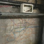
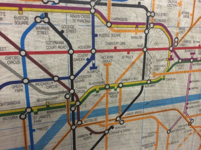
 With the escalator works taking place at Embankment station at the moment, during the installation of what looks like a new electrical box, workmen stumbled across an old map, hidden behind the white panelling that makes up the walls.
It’s on the eastbound platform of the District/Circle Line and is partially obscured by a mesh that covers it, but you can still clearly see a map from, well, what year?
“Get to know your London Connections!” says the map, with all the tube lines in their normal colours and every other railway in Overground orange!
But this is before the Overground, that’s not there; and the DLR is not there either so it must be pre-1987!

 Look closer for more clues, and you’ll see that Broad Street is marked on the map – right next to Liverpool Street – which dates it to before 1986 when that closed. Then, we spotted Stepney East railway station! That is what we now know as Limehouse Station and was called that up until 1987.
The ‘escalator link’ between Bank and Monument is shown, and the North London line too carries on past Stratford down to Woolwich … all great memories of what London used to look like.
 The biggest give-away clue is that that Heathrow Terminal 4 on the map was shown as being ‘Under Construction’. It opened in April 1986.
We did some research and found that the map was produced by Cooper Thirkell and that the release of this map coincided with the Greater London Concil’s introduction of the Capitalcard – which later became renamed the Travelcard.
But overall it makes us wonder – all those station with modern white undecorated fascias, what other tiles and old maps linger behind them, untouched for many many years … ?
The final C-stock ran today with a farewell tour – here it is, approaching Barking nicely juxtaposed against the S7 unit that has replaced it.
Diamond Geezer has an excellent write-up here, and Kateeh has an excellent Flickr gallery here.
With thanks to Bjoern Draegert for spotting these at Old Street.
Due to some redecoration work being done on some of the modern day information panels, they revealed beneath them some really old Northern Line timetables from 1977 that show what the pattern and frequencies of the trains were like back then.
We’re slightly confused by the the two separate columns for trains to High Barnet and trains to Mill Hill East. Did there used to be a time when the service to MHE was not a shuttle and trains just ran directly through all the time?
This was when the Bank branch of the Northern Line was running a regular service – it wasn’t too long ago before this that Northern Line services only ran 3-car trains during the off peak hours, because there wasn’t the demand for the service when people weren’t travelling to the city.
The map at the bottom is a neat thing to see too, showing the Northern Line as it was almost 40 years ago.