Meanwhile, back on the Barcelona subway – here’s something else that we saw at almost every station and really liked. Station Master is all about giving you a visualisation of a station and telling you what is the best exit position to be in on the train, and here’s something simple which London Underground don’t do (but they could) which would aid just that.
They have street map diagrams at all stations, and on them they show where the platforms physically lie below street level, and they then mark on with a bright ‘M’ where the entrance/exit point is to the Metro. This acts as a great guide for helping you work out which end of a train you should be at to be at the nearest point to you above ground destination. Maybe it’s something we could try out in Station Master …
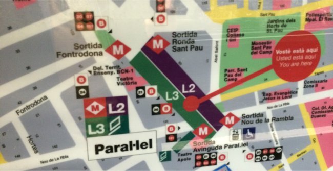
Street Map Diagrams
Our other Station Master notes that this will be something that will be very important to know in London when Crossrail opens in just under 5 years time (December 2018).
The platforms in the central tunnelled section are 250 metres long; so while at Bond Street Crossrail station for example, one entrance will be physically next to the current Bond Street Underground station the other entrance will be in Hanover Square (think behind the Apple Store at Regent Street). Likewise, at Liverpool Street Crossrail station, one entrance is over the road from Liverpool Street station itself (with a connection to the Underground there) while the other entrance is actually in Moorgate, again with a connection to the Underground – get the wrong end of the train at stations like these and you’re in for a long walk from one end of the platform to the other or perhaps even a longer one at the surface!